
ECOSYSTEM INTELLIGENCE (EI) DESIGN MODULE
Apply site-level data and design interventions to maximize benefit.
Getting an accurate picture of site or landscape performance has never been easier. Field data is automatically aggregated into friendly visualizations that demonstrate the combined impacts and benefits as you explore different land use and design decisions.
Integrate site-specific data
Evaluate design alternatives
Monitor and verify
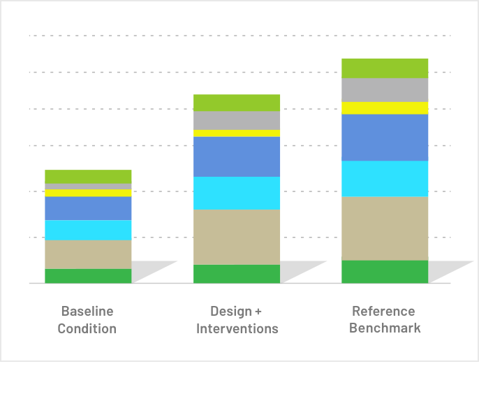
Create infinite design scenarios and compare the impacts expected.
Visualize stacked benefits across each alternative and compare to reference benchmark conditions
Drill-down into reporting on a wide range of ecological functions and services.
Uses site-specific data gathered through remote sensing, desktop research, and the EI Field App.
Existing site conditions and project outcomes can be confirmed by certified third-party Verifiers.

Guided data collection.
Document actual on-the-ground conditions by mapping the habitats and developed areas across your site. The EI Field App is intuitive for users of any skill level, from experts to those with limited ecological background and training. To help users get the most from the platform—and the outputs they generate—we also offer guided training and certification.
Intuitive reports.
EI platform models are designed to have multiple types of output formats. Each of these formats provides different benefits for supporting ecosystem services (ES) analysis.
Percent Performance and Function/Service Acres
The two primary units used to understand site performance at a systems level are percent performance and function/service acres. These units demonstrate the push-pull that occurs when optimizing for function and service performance. They are best understood in comparison to highly functioning reference site performance. For most biomes, generic reference site benchmark information is provided for the user.
Engineering Unit Output
The “engineering unit” is an absolute output typical of engineering analyses. The engineering unit does not lend itself to holistic consideration of a natural system, but it provides a useful way to compare gray versus green infrastructure solutions, and to value replacement costs for lost ES.
Performance Heat Maps
ES are by nature place-based and have an important spatial aspect. For that reason, EI platform outputs can be viewed as “heat maps”, which reflect the respective levels of performance across an analysis area. This type of output is useful for siting decisions and for understanding the strength or degree of benefit production on a given spot on the ground under different scenarios.

'%3e%3cg id='Final-Copy-2_2_' transform='translate(1275.000000, 200.000000)'%3e%3cpath class='st0' d='M7.4,12.8h6.8l3.1-11.6H7.4C4.2,1.2,1.6,3.8,1.6,7S4.2,12.8,7.4,12.8z'/%3e%3c/g%3e%3c/g%3e%3c/g%3e%3cg id='final---dec.11-2020'%3e%3cg id='_x30_208-our-toggle' transform='translate(-1275.000000, -200.000000)'%3e%3cg id='Final-Copy-2' transform='translate(1275.000000, 200.000000)'%3e%3cpath class='st1' d='M22.6,0H7.4c-3.9,0-7,3.1-7,7s3.1,7,7,7h15.2c3.9,0,7-3.1,7-7S26.4,0,22.6,0z M1.6,7c0-3.2,2.6-5.8,5.8-5.8 h9.9l-3.1,11.6H7.4C4.2,12.8,1.6,10.2,1.6,7z'/%3e%3cpath id='x' class='st2' d='M24.6,4c0.2,0.2,0.2,0.6,0,0.8l0,0L22.5,7l2.2,2.2c0.2,0.2,0.2,0.6,0,0.8c-0.2,0.2-0.6,0.2-0.8,0 l0,0l-2.2-2.2L19.5,10c-0.2,0.2-0.6,0.2-0.8,0c-0.2-0.2-0.2-0.6,0-0.8l0,0L20.8,7l-2.2-2.2c-0.2-0.2-0.2-0.6,0-0.8 c0.2-0.2,0.6-0.2,0.8,0l0,0l2.2,2.2L23.8,4C24,3.8,24.4,3.8,24.6,4z'/%3e%3cpath id='y' class='st3' d='M12.7,4.1c0.2,0.2,0.3,0.6,0.1,0.8l0,0L8.6,9.8C8.5,9.9,8.4,10,8.3,10c-0.2,0.1-0.5,0.1-0.7-0.1l0,0 L5.4,7.7c-0.2-0.2-0.2-0.6,0-0.8c0.2-0.2,0.6-0.2,0.8,0l0,0L8,8.6l3.8-4.5C12,3.9,12.4,3.9,12.7,4.1z'/%3e%3c/g%3e%3c/g%3e%3c/g%3e%3c/g%3e%3c/svg%3e) Your Privacy Choices
Notice at Collection
Your Privacy Choices
Notice at Collection